The Challenge
When You Can't See What You're Looking For, Every Centimeter Counts
Before deploying to a remote search area, teams should verify GNSS correction coverage for remote operations to confirm whether Network RTK or PPK will be more reliable.
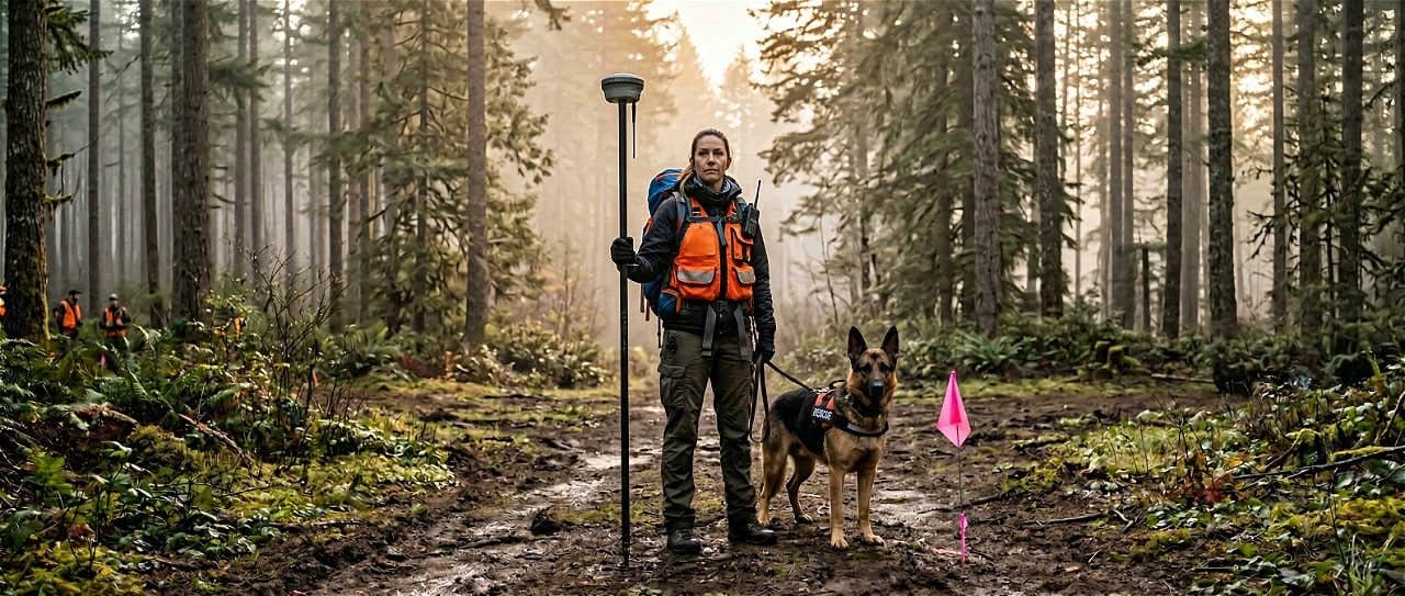
Two organizations in Washington State, working in adjacent but distinct spheres. Cairn Canine Detection (CCD) runs noninvasive historical-burial surveys, cemetery restoration projects, and selected cold cases using dogs trained to detect the scent of human remains. Washington State SAR Planning Unit (WASSPU) provides search-and-rescue planning expertise to local command staff during extended or complex SAR incidents, including evidence searches where dog teams (such as CCD's) are called in. CCD has the dogs; WASSPU handles search management. Both operate across Washington State, both run on volunteers, and both record positions in the field where centimeters can decide whether a follow-up team finds something or doesn't.
"The scent of human remains stays in the ground for hundreds of years, even if the body has been removed. Our intent is to 'narrow' the search area for others to follow up with, either with GPR or excavation."June Mansfield, Cairn Canine Detection and Washington State SAR Planning Unit
Here's the operational problem: when a dog alerts on a location, the handler plants a flag and records GPS coordinates. But flags get removed — by weather, by animals, by time. Weeks or months may pass before a follow-up team arrives with ground-penetrating radar or excavation equipment. At that point, the recorded GPS coordinates are the only link to the exact spot where the dog alerted.
And with standard GPS, those coordinates are wrong. Not slightly off. Operationally, dangerously wrong.
The Numbers That Weren't Good Enough
The teams had been using two common approaches:
- Handheld GPS devices (Garmin and similar): typical accuracy of 8-15 feet (2.5-4.5 meters), often worse under tree canopy
- Smartphone GPS apps on iPhone 16 Pro: similar or worse accuracy, with no real-time correction
For a K9 detection team trying to guide an excavation crew to the exact spot where a dog alerted in a featureless forest floor, 4 meters of error is the difference between finding evidence and missing it entirely.
"Because nothing is visible to the naked eye, we want an absolutely accurate location of exactly where the dog alerted."June Mansfield
The Solution
RTK Corrections Without the Infrastructure
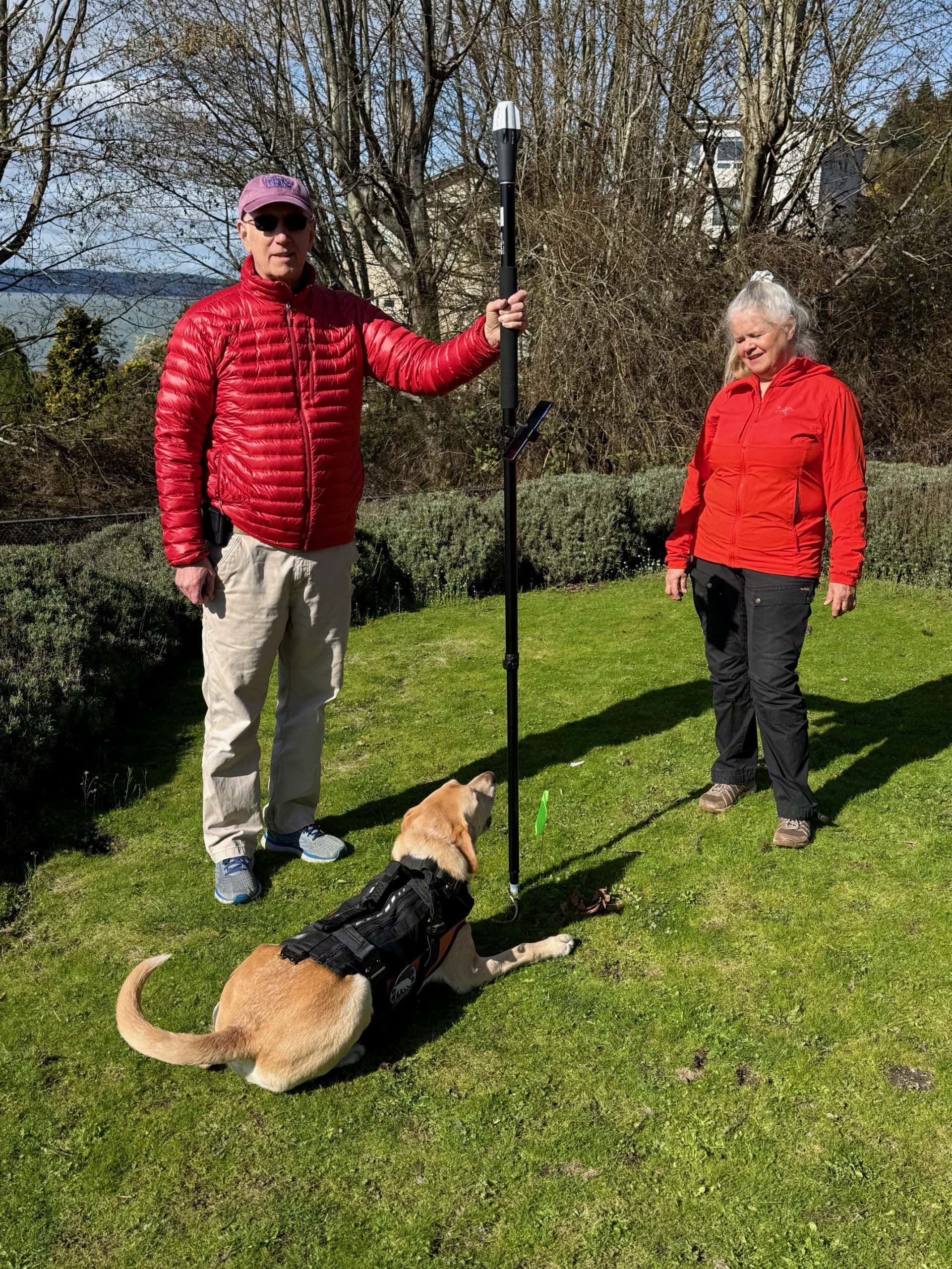
Both organizations chose the Emlid Reach RX2 — a compact, field-ready multi-band GNSS receiver — paired with RTKdata's NTRIP correction service.
The setup is straightforward:
- Create an RTKdata account and start the 30-day free trial
- Enter the NTRIP credentials into the Emlid receiver's correction profile
- Walk into the field and start collecting centimeter-accurate positions
No base station to transport, set up, or secure. No post-processing. No specialized IT knowledge required.
"Love how easy the NTRIP profile is to set up."June Mansfield
A Pricing Model That Fits Volunteer SAR
RTKdata's Standard subscription can be activated monthly and paused when not needed. Both Cairn Canine Detection and WASSPU activate their subscriptions only during deployment periods, paying roughly $40 for the months they're in the field, nothing when they're not.
For organizations that might deploy 6-10 times per year, this means correction service costs of $240-$400 annually instead of thousands for a base station or a locked-in annual contract.
The Results
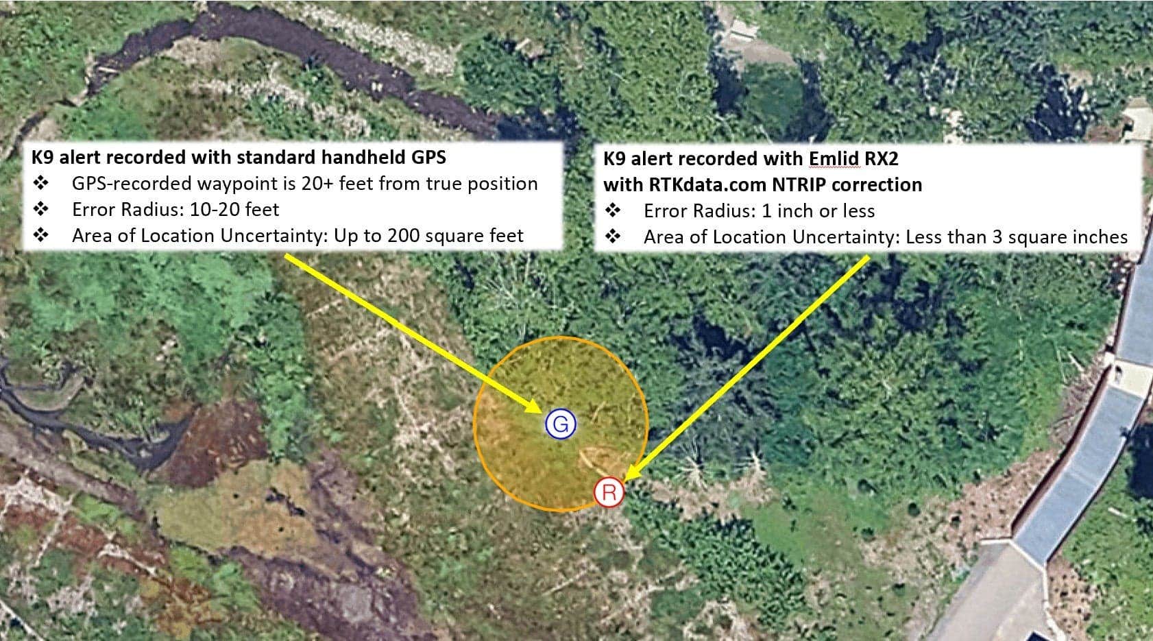
Side-by-Side: RTK vs. Smartphone vs. Handheld GPS
June conducted controlled comparison tests, standing at a known point and recording positions simultaneously with the Emlid RX2 (RTKdata NTRIP) and the GPS on an iPhone 16 Pro.
| Method | Typical Accuracy | Test Result |
|---|---|---|
| Emlid RX2 + RTKdata NTRIP | 1-2 cm horizontal | "Exactly where I was standing" |
| GPS on iPhone 16 Pro | 3-5 m typical | 13 feet (4 m) off |
| Handheld GPS (Garmin) | 2.5-4.5 m typical | 8-15 feet off |
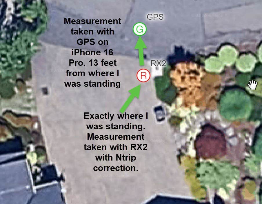
"This morning I did a test in my front yard with the RX2 using the NTRIP test profile. It shows exactly where I was standing. At the same time I took a measurement with the GPS on my iPhone 16 and it was 13 feet away from where I was standing. The RX2 fix is always spot on, and handheld is off 8-15 feet."June Mansfield
Real-World Illustration: When the Flag Is Gone
The clearest illustration of why centimeter accuracy matters comes from a Cairn Canine Detection cemetery survey done before RTK was part of the workflow. One of the trained dogs alerted at a specific spot. The handler placed a pink flag. Nothing was visible at the surface, just dirt and grass.
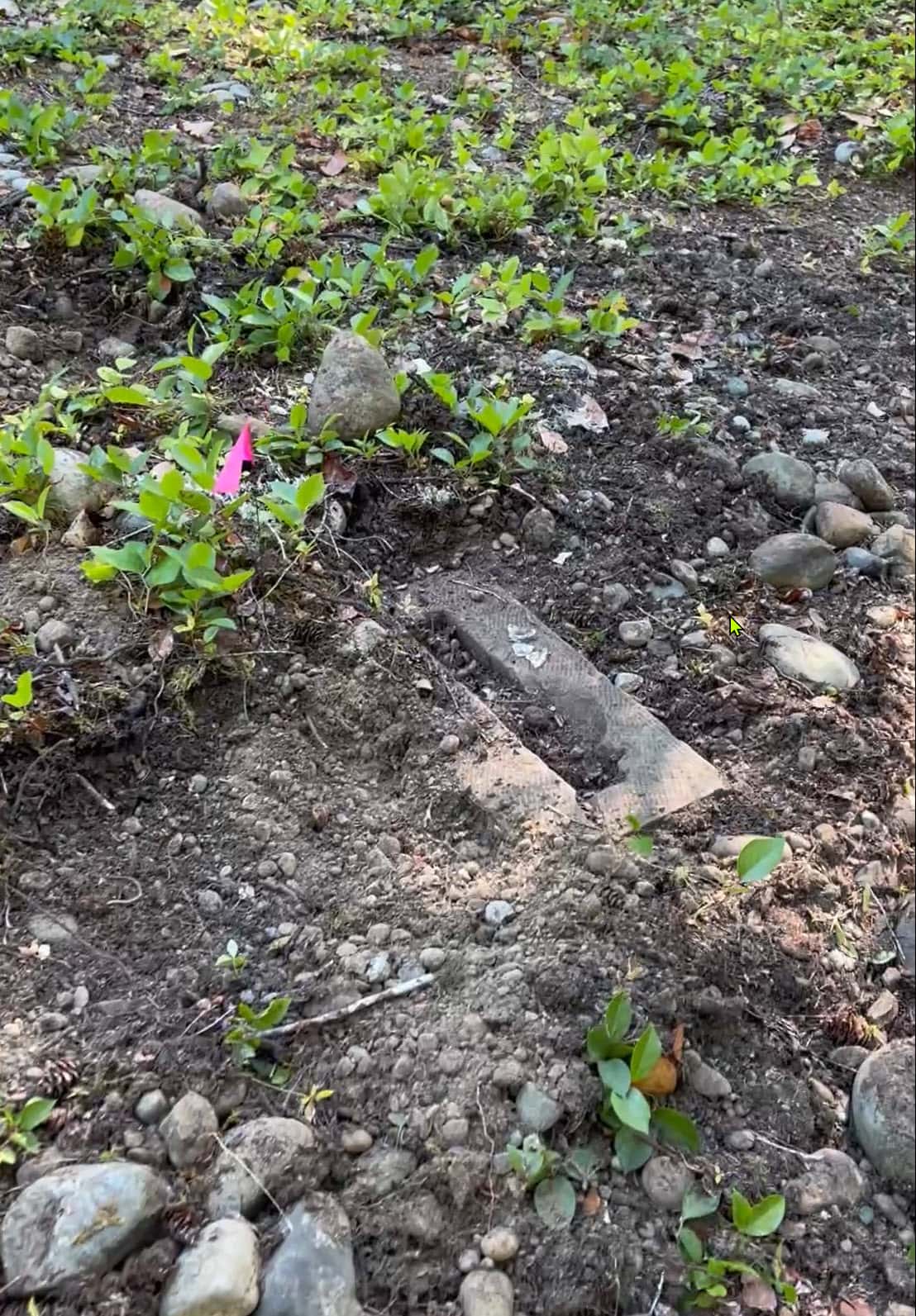
Months later, the excavation team returned. The flag was still there, and the dig confirmed what the dog had detected: a buried headstone, completely hidden beneath the soil. The dog had been right.
That story has a happy ending only because the flag survived. Often it doesn't. Weather, animals, routine site maintenance, and time remove flags between the alert and the follow-up dig. Before RTK, once the flag was gone, finding the spot again at handheld GPS accuracy (8 to 15 feet of error) was effectively starting the search over.
With centimeter-accurate RTK coordinates recorded at the moment of the alert, the flag becomes optional. The position itself is the marker, repeatable to within inches months or years later, regardless of what the surface looks like when the follow-up team arrives. That is the operational chain RTK makes possible: dog alerts → handler records centimeter-accurate coordinates → follow-up team navigates to the exact spot weeks or months later, with or without a surviving flag.
With 8-15 feet of handheld GPS error, that chain breaks.
Accuracy Comparison: Handheld GPS vs. RTKdata NTRIP
Customer Testimonial
"Love how easy the NTRIP profile is to set up, so we will surely be continuing with paid subscriptions when needed. The RX2 fix is always spot on. Because nothing is visible to the naked eye, we want an absolutely accurate location of exactly where the dog alerted."June Mansfield, Cairn Canine Detection and Washington State SAR Planning Unit
Technical Setup
| Component | Detail |
|---|---|
| GNSS Receiver | Emlid Reach RX2 (multi-band, multi-constellation) |
| Correction Service | RTKdata NTRIP RTK |
| Correction Format | RTCM 3.2 |
| Constellations | GPS, GLONASS, Galileo, BeiDou |
| Connectivity | Smartphone hotspot → NTRIP client on receiver |
| Achieved Accuracy | 1-2 cm horizontal (RTK fix) |
| Deployment Model | Monthly activation, paused between deployments |
| Organizations | 2 (Cairn Canine Detection + WASSPU), 1 Emlid RX2 each |
What's Next
With two organizations now equipped and validated, the potential for broader adoption across the K9 detection and SAR community is clear. K9 detection teams, SAR planning units, and archaeological survey groups face the same fundamental problem: they need to return to exact locations in featureless terrain, often weeks or months after the initial visit.
The combination of affordable multi-band receivers like the Emlid RX2 and NTRIP RTK correction services removes the last major barrier — cost — that kept centimeter-level positioning out of reach for volunteer and nonprofit field teams.
Frequently Asked Questions
Can RTK GPS be used for search and rescue operations?
Yes. K9 detection teams in Washington State use RTKdata's NTRIP RTK corrections with the Emlid Reach RX2 to achieve centimeter-level accuracy when recording dog alert locations during cemetery surveys, cold cases, and SAR evidence searches, replacing handheld GPS devices with 8-15 feet of error.
How accurate is RTKdata NTRIP compared to handheld GPS?
In controlled side-by-side tests, the Emlid RX2 with RTKdata NTRIP showed the exact position ("exactly where I was standing"), while the GPS on an iPhone 16 was 13 feet off and a handheld Garmin GPS was 8-15 feet off. RTKdata delivers 1-2 cm horizontal accuracy.
Do volunteer SAR teams need a base station for RTK accuracy?
No. RTKdata provides network RTK corrections via NTRIP over a cellular connection, eliminating the need for a physical base station ($5,000-$15,000). Teams connect via smartphone hotspot and achieve centimeter accuracy in real time.
What does RTKdata NTRIP cost for volunteer organizations?
RTKdata's Standard subscription is approximately $40/month and can be activated or paused at any time. Volunteer SAR teams activate only during deployment periods, resulting in annual costs of $240-$400 instead of thousands for base station infrastructure.