RTK Corrections in the United States
RTK corrections across the United States deliver 1-2 cm horizontal accuracy to any RTCM3-compatible device via NTRIP. RTKdata covers all 50 states on a single $40/mo subscription, replacing fragmented state CORS networks. Plans start at $40/month with a 30-day free trial, no credit card required.
- All 50 states, one subscription
- Surveying, farming, drones, construction
- $40/mo vs $100-150 competitors
- 30-day trial, no credit card
Why US Professionals Choose RTKdata
50-State Coverage
One subscription replaces the patchwork of state CORS systems. No per-state registration, no access restrictions, no worrying about which states offer free RTK and which do not. A single set of NTRIP credentials works from coast to coast.
$40/mo, No Dealer Required
Most RTK providers charge $100-150/mo or hide pricing behind a sales call. RTKdata publishes pricing at $40/mo or $400/yr with instant self-service activation. No contracts, no dealer, no quote requests.
One Protocol, Every Industry
Works with any device that accepts RTCM 3.x corrections via NTRIP. Survey rovers, DJI drone controllers, tractor auto-steer systems, construction machine guidance units, and autonomous platforms all connect the same way. No vendor lock-in.
Free 30-Day Trial
Test corrections on a California construction site, a Kansas wheat field, or a North Dakota pipeline corridor before paying. Full access to all US stations and the global network. No credit card required, and the trial ends automatically with no billing.
Industries Using RTK Corrections in the United States
Land Surveying
The US employs 53,080 licensed surveyors (Source: BLS, May 2024). ALTA/NSPS boundary surveys require a maximum Relative Positional Precision of 2 cm, which is the exact accuracy network RTK delivers (Source: NSPS 2021 Standards). Updated 2026 ALTA/NSPS standards are now published. Professional liability claims for positioning errors that exceed specified tolerances drive malpractice insurance premiums, making RTK's defensible accuracy records an increasingly important risk management tool.
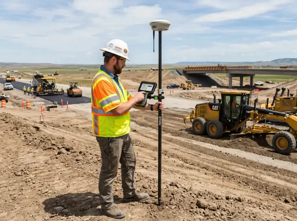
Construction
US construction spending reached $2.23 trillion in 2025, with $1.2 trillion authorized under the Infrastructure Investment and Jobs Act (Source: U.S. Census Bureau, 2025). GNSS-based machine control for dozers, graders, and excavators holds the largest market share in the $6.03 billion machine control system market (Source: U.S. Census Bureau, 2025). State DOTs in Utah, Pennsylvania, and Minnesota now require 3D models for highway projects, making GNSS machine control standard practice on federally funded work.
Agriculture
The US precision farming market reached $4.37 billion in 2025 across 1.88 million farms managing 876 million acres (Source: USDA ERS, 2024). Auto-steer adoption at 70% among large-scale crop farms makes RTK the standard input for planting, spraying, and harvesting with sub-inch pass-to-pass accuracy (Source: USDA ERS, 2025). USDA EQIP and CSP programs subsidize GPS guidance as a conservation practice, and Chesapeake Bay watershed states increasingly require GPS-documented nutrient application records.
Drones and UAS
Over 420,000 commercial drones are registered with the FAA under Part 107 as of 2025 (Source: FAA, 2025). RTK-equipped platforms from DJI, senseFly, and Emlid reduce or eliminate ground control points, saving 30-60 minutes per flight mission on volumetric surveys, corridor mapping, and construction progress monitoring. The FAA Part 108 BVLOS rule, expected to finalize in 2026, will eliminate individual waivers for beyond-visual-line-of-sight operations, massively expanding drone surveying and delivery use cases that depend on RTK-grade positioning.
Oil and Gas
The Permian Basin alone produces 6.6 million barrels per day, 48% of total US crude output (Source: EIA, 2025). Pipeline route surveys spanning 100+ mile corridors across West Texas, the Bakken in North Dakota, and the Eagle Ford formation need continuous RTK where state CORS networks have coverage gaps.
Utilities and GIS
GIS technicians, utility locators, and field engineers map poles, underground conduits, and transmission lines at centimeter accuracy for asset inventory and compliance. ASCE 38-22 Subsurface Utility Engineering standards require RTK for Quality Level A precise horizontal and vertical location of underground assets. Dense urban areas in New York, Chicago, and Los Angeles present multipath from high-rise corridors. Multi-constellation tracking (GPS, GLONASS, Galileo, BeiDou) maintains fix rates where single-constellation receivers lose lock.
Autonomous Vehicles and Delivery Robots
NHTSA's April 2025 AV Framework relaxed manual control requirements, accelerating self-driving deployments in Arizona, California, and Texas. Autonomous sidewalk delivery robots are now legal in 20+ states. HD map creation for self-driving systems requires centimeter-accurate road geometry capture, and RTK survey vehicles are the primary data collection method. The convergence of V2X connected vehicle infrastructure and lane-level positioning creates sustained demand for RTK-grade ground truth data.
Solar and Renewable Energy
Utility-scale solar farm construction requires RTK for panel array layout, terrain grading, and tracker alignment across sites spanning hundreds of hectares. Wind turbine foundation staking depends on centimeter positioning for monopole placement. The Inflation Reduction Act has driven over $200 billion in clean energy investment commitments since 2022, and carbon credit verification programs such as Verra and Gold Standard increasingly require precise measurement of no-till zones, cover crop areas, and soil sampling locations tied to GPS records.
How to Connect to RTK Corrections in the United States
Three steps from signup to centimeter positioning on any US job site.
01
Choose a Plan
Pick a subscription or start the 30-day free trial. No credit card is needed. Test corrections on a California construction site, a Kansas wheat field, or a North Dakota pipeline corridor before selecting a paid plan.
02
Enter NTRIP Credentials
Add the server address, port, and AUTO mountpoint to your rover or field controller. Set coordinate output to your State Plane zone or UTM zone. Configuration takes under five minutes on any RTCM3-compatible device, from survey rovers and drone controllers to tractor auto-steer terminals and machine guidance systems.
03
Verify RTK FIX
Check the receiver display for a fixed RTK solution. Open-sky conditions on farmland or cleared construction sites produce a fix within seconds. Dense urban areas like Manhattan or downtown Chicago may require multi-constellation tracking to maintain lock through signal reflections.
GNSS in US Projects: Infrastructure Act & Offshore Wind
$1.2 trillion
IIJA federal infrastructure investment through 2026
$110 billion
Dedicated to highway and bridge reconstruction
30 GW
US offshore wind target by 2030
806 MW
Vineyard Wind 1, first US commercial-scale offshore farm
2.6 GW
Coastal Virginia Offshore Wind capacity
$16 billion
Gateway Tunnel program (NY/NJ Hudson River crossing)
53,080
Licensed US land surveyors (BLS, 2024)
2027
NATRF2022 replaces NAD83 as national datum
RTK Providers in the United States: Feature Comparison
Pricing, station count, and activation compared across seven correction services available to US professionals.
| Criterion | RTKdata | State DOT CORS | E38/RTK Premium | Point One Polaris | Skylark | Trimble VRS Now | Leica SmartNet |
|---|---|---|---|---|---|---|---|
| US stations | 5,000+ | ~2,000 (NOAA CORS-N) | Aggregated state CORS | ~3,000 | Undisclosed (wider spacing) | ~1,000+ | 1,500+ |
| Monthly price | $40/mo | Varies by state (free to ~$1,000+/yr) | $100/mo | $150/mo | $69/mo | No public information | No public information |
| Annual price | $400/yr | Free (where available) | $900/yr | $1,500/yr | $699/yr | No public information | No public information |
| Free trial | 30 days, no credit card | N/A | Varies | 14 days | Varies | No public information | No public information |
| 50-state coverage | Yes | Partial (~20 states with public access) | Yes | Regional (expanding) | Yes (1M+ sq mi) | Yes (all 50 states) | Yes (all 50 states) |
| Correction type | True RTK (RTCM 3.x) | True RTK (RTCM 3.x) | True RTK + Virtual RTK | PPP-RTK (convergence delay) | True RTK | True RTK | True RTK |
| Activation | Self-service to enterprise deployment | Per-state registration | Self-service | Self-service | Self-service | No public information | No public information |
| Hardware lock-in | None. Any RTCM3 device | Any (where allowed) | None | None | None | Optimized for Trimble | Optimized for Leica |
| Global coverage | 20,000+ stations, 140+ countries | US only | US only | US, Europe, Asia-Pacific | US, EU, Asia | Global (urgent expand) | Global (urgent expand) |
| Height output | Ellipsoidal (apply geoid model) | Varies | Ellipsoidal | Ellipsoidal | Ellipsoidal | Via geoid model | Via geoid model |
Last updated: April 14, 2026. Competitor pricing verified from provider websites. State DOT pricing varies. Skylark from Swift Navigation. Contact providers for current rates.
US Coordinate Reference Systems
Corrections arrive in ETRS89. Project into UTM Zone 32N (EPSG:25832). Heights are ellipsoidal; load DVR90(2023) for orthometric values. For full datum documentation, see the setup guide.
| System | Details | Notes |
|---|---|---|
| NAD83(2011) | Current legal datum for all US RTK corrections | Replaced by NATRF2022 in 2027 |
| State Plane / UTM | 125 SPCS zones or UTM 10N-19N for projections | SPCS2022 expands to 967 zones |
| GEOID18 / GEOID2022 | Geoid models for orthometric height conversion | Differences exceed 10 cm regionally |
RTK in the United States - FAQ
How much does RTK correction service cost in the US?
RTK correction subscriptions in the US range from $40/mo to $150/mo depending on the provider. RTKdata charges $40/mo or $400/yr with no contracts and no hardware lock-in. Skylark from Swift Navigation runs $69/mo or $699/yr. Trimble VRS Now and Leica SmartNet require contacting a dealer for pricing. About 20 states offer free access through state DOT CORS networks, though many restrict usage to government contractors.
Do I need a base station for RTK in the US?
Which GNSS receivers work with NTRIP?
How does RTK compare to PPK for surveying?
Can I use RTK corrections for drone mapping under Part 107?
Is there a free RTK service in the United States?
How do GEOID18 and GEOID22 affect RTK height accuracy?
One Subscription for RTK Corrections Across All 50 States
From the Permian Basin oil fields to Midwest farmland to East Coast boundary surveys, 5,000+ reference stations deliver NAD83(2011) corrections through a single NTRIP connection. Set up your receiver, confirm a fixed solution, and start working at 1-2 cm accuracy within minutes. Plans begin at $40/month with a 30-day free trial.