

Estimated reading time: 8 minutes
High-precision positioning is the heart of drone mapping accuracy. When teams compare UAV RTK vs PPK, they want maps that line up to the real world within centimeters. UAV RTK (Real-Time Kinematic) and UAV PPK (Post-Processed Kinematic) are GNSS correction methods that enable this level of precision. Both are vital for precise georeferencing; the better fit depends on speed, connectivity, and project needs. This guide shows how to choose, with tips on camera timing and lever-arm calibration.
Table of contents
Start your 30-day free trial
Evaluate real-time reliability for connected missions with quick NTRIP setup and immediate geotags for fast turnaround.
Summary
RTK gives real-time corrections and instant geotags, best when you have steady connectivity and need quick delivery. PPK applies corrections after flight, best for remote or long missions where links are weak. Both can reach cm-level accuracy when camera timing and lever-arm offsets are set correctly.
Key takeaways
- Both RTK and PPK deliver survey-grade accuracy. Choose based on speed, connectivity, terrain, scale, and workflow.
- RTK: real-time corrections and immediate geotags; typical accuracy 1-2 cm horizontal, 2-3 cm vertical in open areas.
- PPK: post-processed corrections; same 1-2 cm horizontal, 2-3 cm vertical range when timing and offsets are right; resilient to in-flight gaps.
- Camera timing (hardware event marking) and lever-arm offsets are critical for map accuracy.
- Plan steady flights with high overlap and use GCPs to verify outputs, regardless of method.
Understanding RTK and PPK positioning
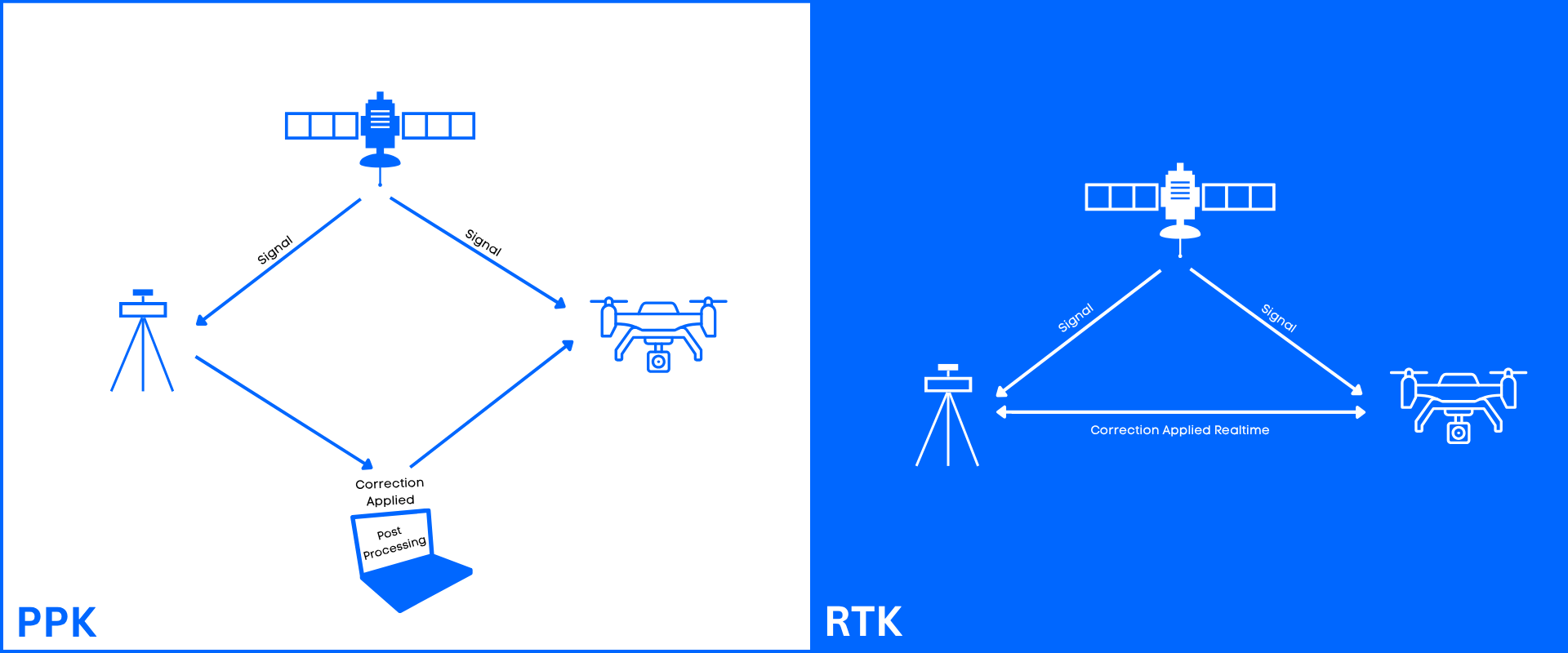
RTK (Real-Time Kinematic) and PPK (Post-Processed Kinematic) both provide centimeter-level survey accuracy for drones by correcting GPS data against a base station.
RTK applies corrections instantly in-flight by using corrections from a base or NTRIP and is ideal for time-sensitive, connected or live-tracking projects. Positions are fixed during flight, so images get immediate geotags. Limits: if the link drops, accuracy can suffer; you need steady network or line-of-sight.
That dependency is a design question rather than a dealbreaker. Corrections reach the rover over NTRIP from a mountpoint on a reference station network, so what matters in practice is how far away the nearest station sits and what happens when a stream stops. RTKdata operates 20,000+ reference stations across 140+ countries.
For monitoring, the useful signal is the age of the corrections, not a connection heartbeat. A socket can stay open while the correction stream has gone stale, and the rover will keep reporting a fix that no longer deserves the confidence. Watching correction age catches that early; a practical target is roughly two seconds or less, though the tolerable figure is application dependent. Failing over to an alternate mountpoint restores the stream without bringing the aircraft down. The handshake, the sourcetable, and retry behaviour are set out in NTRIP connection flow explained.
PPK processes data after the flight, offering higher reliability in remote, obstructed, or long-range scenarios. The method records GNSS data and events onboard and applies corrections later. PPK stays reliable even with in-flight gaps, but it adds time and software steps. The accuracy either one reaches comes from the same set of error terms, broken down further down this page.
Open RTKdata Docs
Review guides for NTRIP setup, camera event marking, and post-processing to keep timing and offsets aligned.
Camera timing and lever-arm calibration
Precise camera timing matters. Tag each photo at the exact capture instant to lock geotag accuracy. Hardware camera event marking beats software triggers and reduces drift. Poor timing creates absolute position errors.
The lever-arm is the GNSS antenna offset from the camera's optical center. If the offset is wrong, every image shifts. Measure offsets on all axes and apply them in real time or during post-processing. Both RTK and PPK need correct timing and offsets to reach full accuracy.
Accuracy budget: what actually drives the error
Final map accuracy is not a single figure handed down by the correction method. It is the sum of several error terms that accumulate independently, and moving between RTK and PPK changes only one of them. Separating the terms makes the choice far easier to judge.
- Baseline length. The further the rover sits from the reference station, the less the atmospheric and orbit errors cancel between the two receivers, so the solution loosens with distance. The breakdown by distance is in NTRIP RTK accuracy vs distance.
- Satellite geometry and sky visibility. The official US GPS performance page is explicit that broadcast signal quality is not user accuracy: "User accuracy depends on a combination of satellite geometry, URE, and local factors such as signal blockage, atmospheric conditions, and receiver design features/quality" (GPS.gov, retrieved August 2026). A thin constellation behind a tree line degrades RTK and PPK alike.
- Camera event timing. A geotag is only as good as the instant it is stamped against, which is why hardware event marking outperforms a software trigger for both workflows.
- Lever-arm offset. An unmeasured antenna-to-camera offset shifts every image by the same amount, and no correction stream repairs it after the fact.
- Independent check. Ground control points do not tighten the solution, they measure it. Without checkpoints you have a precision figure and no evidence of absolute accuracy.
Only the correction timing term genuinely differs between the two. RTK resolves it in flight and degrades if the link drops; PPK resolves it afterwards from logged data and can reprocess a span that went bad. Every other line on that list is the same work either way, which is why both land in the same range on a properly flown mission: about 1-2 cm horizontal and 2-3 cm vertical.
Comparing RTK and PPK for UAV mapping
Follow smart flight planning: keep steady speed and altitude, fly straight lines, aim for ≥80% overlap, and avoid sharp turns. Use GCPs to verify the model: survey well-spread points and check outputs against them.
Key Differences:
- Correction Time: RTK is instantaneous; PPK is post-flight
- Data Link: RTK requires a stable, constant connection (radio/cellular) between the drone and base station. PPK does not require a live link
- Reliability: PPK is more robust in areas with poor signal (urban canyons, dense forests)
- Workflow: RTK offers immediate feedback for faster, on-site checkups. PPK requires extra, time-consuming office work to process data
- Accuracy: Both reach the same centimeter-level range, about 1-2 cm horizontal and 2-3 cm vertical, when timing and offsets are correct
- Multipath: reflections near buildings, trees, or water affect both methods; PPK can often recover the affected span in post-processing
RTK vs PPK practical checklist
- Pre-flight: Confirm RTKdata NTRIP or base; verify camera timing; check lever-arm values; plan coverage/overlap; place and survey GCPs.
- In-flight: RTK → monitor link and Fix state; PPK → confirm GNSS logs and camera events; hold planned speed/height.
- Post-flight: RTK → review real-time stability; PPK → complete post-processing; always validate against GCPs and note issues.
Plan your next mission with RTKdata
Discuss fleet needs, connectivity, and the best-fit RTK or PPK workflow, or try real-time corrections on your routes.
Frequently asked questions
Is RTK or PPK more accurate for drone mapping?
Neither has an inherent edge. Both reach about 1-2 cm horizontal and 2-3 cm vertical when camera event timing and lever-arm offsets are correct; what differs is how the correction reaches the rover, not the accuracy ceiling.
What happens if the RTK link drops mid-flight?
The rover falls back from a fixed solution to float or autonomous, so images taken during the gap lose their centimeter geotags and sit closer to standard GPS accuracy. Failing over to another mountpoint restores the stream; in a PPK workflow the affected span can often be recovered in post-processing.
Is RTK or PPK faster to deliver results?
RTK. Positions are fixed during the flight, so images carry usable geotags as soon as the aircraft lands. PPK adds a post-processing step in the office before results can be checked.
What does PPK stand for?
Post-processed kinematic. The receiver logs raw GNSS data and camera events onboard, and corrections are applied after landing rather than during the flight.
Do you still need Ground Control Points with RTK or PPK?
Yes, at least as checkpoints. A Ground Control Point (GCP) is a surveyed marker placed on the site; it does not tighten the GNSS solution, it measures it. Without independent checkpoints you have precision and no evidence of absolute accuracy.

Inbound and outbound sales for SMB and mid-market customers at RTKdata.