The Challenge
Why agricultural drone mapping in South Dakota requires reliable RTK
Mel LeVeque is a military veteran who first learned drones the hard way: in deployment, where the equipment had to work the first time and every time. When he came home to South Dakota, he saw a state with millions of acres of corn and soybean ground and one obvious gap. The big-iron precision-agriculture tools were built for Iowa-and-Illinois fields. South Dakota fields are large, rocky, and a long drive from the next service truck. Drones, flown well, could close the gap.
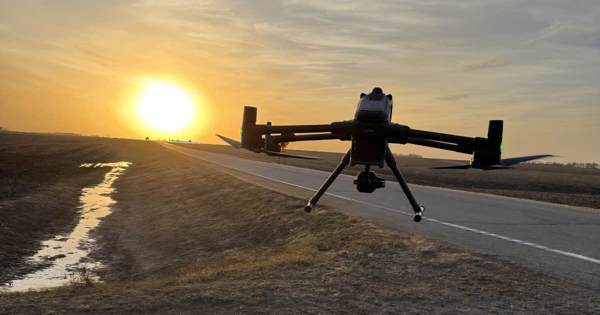
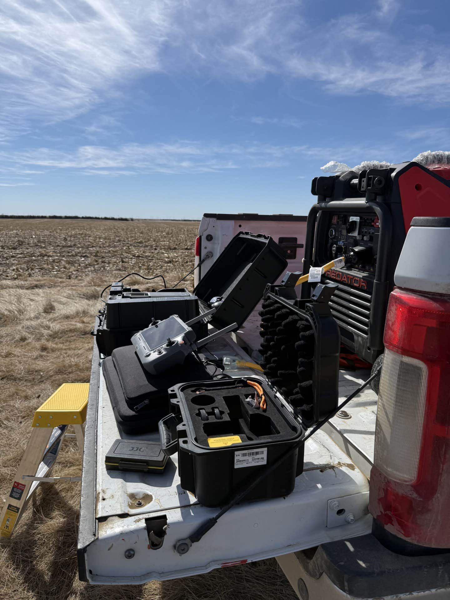
So he started AeroAg Drone Services in Highmore, SD, with a small fleet of DJI Matrice 400 enterprise drones, a Starlink-equipped service truck for connectivity in the middle of nowhere, and a partnership with TerraClear, the AI rock-mapping pipeline that ingests drone imagery and tells a skid-steer where to drive next.
The model only works if RTK works. When RTK fails, the drone is grounded, and a grounded drone in spring planting season is not a minor inconvenience.
From a previous RTK provider to a single $37,500 lost job
The failure mode that pushed Mel to switch was specific and expensive. He was running a large job for an important farmer. Tight window, multiple pilots in the field, the kind of job that defines a season. RTK would not converge. A converging RTK fix is what tells the drone "you are here, exactly here." Without convergence, the drone either refuses to fly the precision pattern or flies it on coordinates that downstream AI tools cannot trust.
"We had a very large job we wanted to knock out in a short period for an important farmer. We were unable to get RTK to connect and it stopped us in our tracks. RTK wouldn't converge and it ended up costing me greatly in missed time and travel costs."Mel LeVeque, Founder, AeroAg Drone Services
The math on that job is brutal in plain English. Five pilots, three days stranded, roughly $2,500 per pilot per day in revenue-plus-cost exposure. That single job cost AeroAg about $37,500 in missed revenue, travel, and farmer-relationship damage.
Why fix-rate inconsistency at the field edge breaks an aerial mapping business
The previous provider worked fine in some places. In others it would take hours to converge if it ever did. For an operator like Mel, "works fine in some places" is not a service. It is a coin flip with a paycheck on the table. A single pilot stranded for a day clears four figures. A whole crew stranded for three days clears five figures. When that happened in spring, with a marquee farmer waiting on his field, Mel started searching for an alternative the same hour.
The Solution
From the previous RTK provider to RTKdata: a 10-minute switch
A point of contact mentioned RTKdata. Mel went to the website, started the free trial, paid the Standard plan, got login credentials, and pushed those credentials to a pilot already on the ground. From "frantic search" to "pilot in the air with valid RTK fix" was about 10 minutes.
"Within 10 minutes I had an account and had a subscription and my pilot on the ground was connected and flying."Mel LeVeque, AeroAg Drone Services
Three things mattered in that 10-minute window. First, a real free trial with no credit-card friction means a pilot in panic mode can subscribe without waiting on procurement. Second, NTRIP credentials work over any internet connection, including the Starlink uplink built into Mel's truck. Third, the protocol is standard RTCM 3.2, so the existing M400 fleet did not need a firmware quirk or a vendor-specific pairing dance.
What the RTKdata setup looks like on a DJI Matrice 400 fleet
AeroAg's working setup is purpose-built for agricultural mapping at scale. The M400 platform sits in the 6 kg payload class with a 59-minute maximum flight time and the new DJI O4 Enterprise transmission link, which is roughly twice the range of the M350 it replaced. Pair that with NTRIP corrections delivered over the truck's Starlink uplink, and a single deployment looks like the table below.
| Setup parameter | Previous RTK provider | RTKdata |
|---|---|---|
| Time to fly with new credentials | Hours, sometimes never | ~10 minutes |
| Trial without credit card | No | Yes, 30 days |
| Convergence reliability in SD | "Fine in some places, hours in others" | Consistent fix across SD, ND, MN |
| Protocol | RTCM (proprietary touches) | RTCM 3.2 standard, no vendor-specific pairing |
| Coverage edge response | Customer absorbs the risk | RTKdata ships base station for 200K-acre project |
| Constellations | Varied | GPS, GLONASS, Galileo, BeiDou |
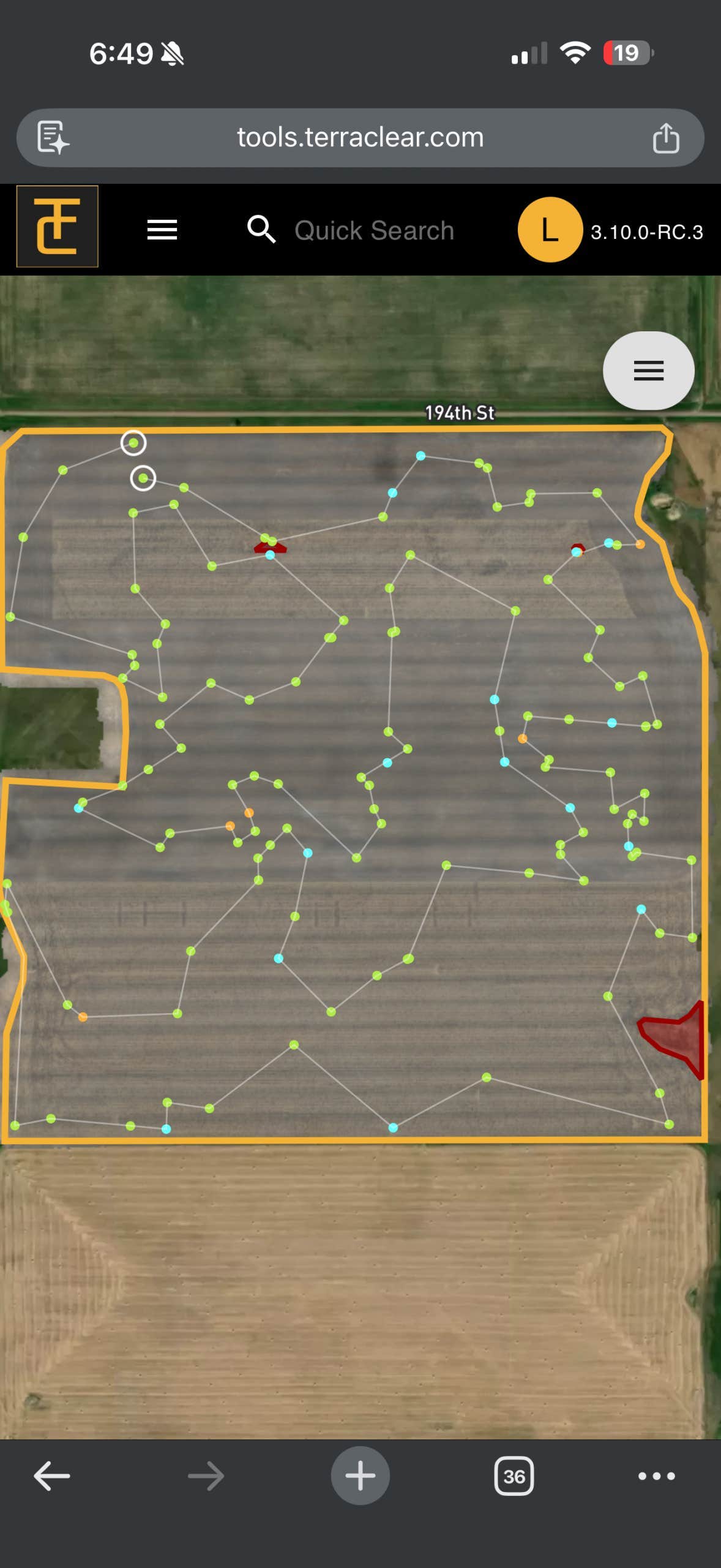
TerraClear pipeline integration: rock mapping, weed mapping, prescription delivery
TerraClear's rock-mapping workflow is straightforward in principle. A drone flies the field at altitude. The imagery goes to TerraClear, AI flags every rock 8 inches or larger by location and size, and a TerraClear skid-steer (or a cooperating ground crew) drives a least-cost path through the rocks. Studies cited by TerraClear suggest manual rock-picking crews miss 60% to 70% of the rocks in a field. An AI-mapped field with georeferenced pickup directions does not.
The accuracy of that whole loop hinges on the drone's georeferenced photo metadata. If the drone says a rock is at coordinate X, but the rock is actually 2 meters away, a downstream operator wastes time at every single rock. With RTK fix held, the photo metadata is centimeter-true, the rock pickup is fast, and the customer pays for an actually completed job.
This is also why Mel's spraying-drone workflow benefits from the same NTRIP service. Chemical application requires the drone to fly the same lines on every pass without overspray or missed strips. RTK keeps the lines parallel and the pesticide on-target.
The Results
What changes when RTK just works on every flight
The honest difference between the previous provider and RTKdata is not a benchmark number. It is a job posture. Pilots launch with a working RTK fix, fly the planned mission on the planned day, and ship a TerraClear-ready imagery set that does not need to be re-flown. The previous provider's "hours to converge if ever" routinely killed flight days. The new setup does not. That is the difference between a business with margin and a business with stress.
Key Metrics
- 10-minute switch from frantic search to a pilot in the air on RTKdata corrections (Mel's actual experience, not marketing claim)
- 1 to 2 cm horizontal accuracy on RTK fix, well inside the TerraClear pipeline's operating envelope
- $37,500 in lost revenue and travel on the previous-provider failure job (5 pilots x 3 days x ~$2,500 per pilot per day)
- 200,000 acres mapping engagement planned north of Highmore, SD, next season
- Zero base stations required for the standard fleet, no in-field hardware investment
- ~$40 per month Standard plan, no contract, no credit card up front
- 3 states served: South Dakota, North Dakota, Minnesota, with one set of credentials
Real-world proof: a Highmore-area mapping fleet feeding the TerraClear rock and weed pipeline
The current operating posture is straightforward. Mel runs three to five pilots out of Highmore, SD, with the fleet fanning out into Minnesota and North Dakota for larger jobs. Each pilot flies an M400 on RTKdata corrections, with the Starlink-equipped service truck acting as both a connectivity hub and a mobile office. The deliverable is a TerraClear-ready imagery set: each frame georeferenced to centimeters, each field flown to the spec the AI pipeline needs.
The chemical-application side of the business uses the same RTK backbone. Drone spray rigs follow planned lines with RTK precision, which keeps drift inside legal margins and chemicals off the wrong field.
The 200,000-acre case for in-state base-station coverage
The biggest near-term project is a 200,000-acre mapping engagement north of Highmore, planned for the next operating season. The challenge: the project sits at the edge of optimal RTKdata coverage in that part of the state. Rather than accept a degraded fix rate or force AeroAg to absorb risk, RTKdata is shipping Mel a base station. The base station tightens the local correction network for that specific project, then continues serving any AeroAg pilot in the region indefinitely. That deal is itself a case study in how a cloud NTRIP service should respond when a serious customer has a serious project.
Customer Testimonial
"It is very simple. If your paycheck relies on RTK, you need something that just works, isn't expensive, and has a fast response to concerns. It's a no-brainer. If RTK doesn't work, you are losing money, and RTKdata simply works."Mel LeVeque, Founder, AeroAg Drone Services LLC
Mel's framing earns its weight from his background. Military veterans who started running drones in deployment do not usually award five-star reviews to gear that occasionally works. The simple-and-it-works claim, in that mouth, is a benchmark, not a marketing line.
"We have brand new M400s and everything is super-high quality and works. RTK was the only thing."Mel LeVeque, on the gap that pushed him to switch providers
The lesson for any operator with a similar profile, brand-new high-end equipment, downstream AI pipelines, paying farmer customers waiting on time-sensitive jobs, is that RTK is not a feature. It is the foundation that decides whether the rest of the stack returns money or burns it.
Technical Setup
| Component | Detail |
|---|---|
| Correction Service | RTKdata NTRIP RTK (cloud-based) |
| Plan | Standard, ~$40/month, no contract |
| Protocol | NTRIP / RTCM 3.2 |
| Constellations | GPS, GLONASS, Galileo, BeiDou |
| Drones | DJI Matrice 400 enterprise (6 kg payload class, 59 min flight time, O4 Enterprise transmission) |
| Connectivity | Starlink mobile uplink (truck-mounted), 4G/LTE backup, NTRIP over IP |
| Achieved accuracy | 1 to 2 cm horizontal when RTK fix held |
| Operating region | South Dakota (primary), Minnesota, North Dakota |
| Pilot count | 3 to 5 currently, plan 7 to 10 by spring 2027 |
| Use cases | Field rock mapping (TerraClear), weed mapping, drone-based chemical application |
| Base station | None on standard ops; one being shipped for a 200,000-acre engagement north of Highmore |
What's Next
The 200,000-acre mapping project is the operational milestone for the next 12 months. Beyond that, AeroAg's plan is to grow the pilot count to 7 to 10 by spring 2027 and expand the service footprint deeper into Minnesota and North Dakota, where the rocky-and-weedy field profile is similar and the TerraClear pipeline is already validated.
In parallel, Mel is exploring whether the same RTK-anchored mapping workflow can be productized for adjacent agricultural use cases, including livestock-pasture inventory and irrigation-pivot inspection. Each of those depends on the same core fact: the drone has to know exactly where it is, on every flight, every time. RTKdata is the layer that makes that fact reliable.
For RTKdata, the AeroAg engagement is also a template for how a cloud NTRIP provider can serve a US Midwest agricultural fleet customer end to end: free trial that closes a sale in 10 minutes when speed matters, Standard plan that holds for everyday operations, and a base-station shipment when a strategic project pushes the edge of the network.
Frequently Asked Questions
Does RTKdata NTRIP work for agricultural drone mapping in South Dakota?
Yes. RTKdata operates a multi-constellation network with more than 20,000 reference stations across 140+ countries, including full coverage of South Dakota, North Dakota, and Minnesota. AeroAg Drone Services flies a DJI Matrice 400 fleet on RTKdata corrections out of Highmore, SD, and operates across the upper Midwest. For projects on the edge of optimal coverage, like AeroAg's planned 200,000-acre engagement north of Highmore, RTKdata can ship a dedicated base station to tighten the local network.
What accuracy does the TerraClear rock-mapping pipeline need from a drone?
TerraClear's AI pipeline locates rocks 8 inches and larger by drone imagery and downstream machine learning. The accuracy of every step in that loop hinges on georeferenced photo metadata: if a drone says a rock is at coordinate X but the rock is actually meters away, downstream operators waste time at every single rock. RTKdata NTRIP corrections deliver 1 to 2 cm horizontal accuracy on RTK fix, well inside the precision the TerraClear pipeline needs.
How fast can a drone operator switch RTK providers if the current one fails mid-job?
For RTKdata, the realistic time from frantic search for an alternative to pilot in the air with valid RTK fix is about 10 minutes. AeroAg's founder Mel LeVeque ran exactly that sequence after his previous RTK provider failed on a high-stakes farmer job: signed up for the Standard plan during the 30-day free trial, pushed credentials to a pilot already on the ground, and was flying with valid RTK fix the same hour. The free trial requires no credit card up front, which is what makes a 10-minute switch realistic during a live job.
How much does a single hour of RTK downtime cost an agricultural drone operator?
By Mel LeVeque's own figures, a single drone down for an hour costs AeroAg $200 to $300 in lost flight revenue. A whole crew stranded for multiple days clears five figures. The job that pushed AeroAg to switch RTK providers cost the company about $37,500 in missed revenue and travel: 5 pilots, 3 days, roughly $2,500 per pilot per day. RTK reliability is therefore not a technical preference. It is a direct line item in the operating P&L.
Does the DJI Matrice 400 work with cloud NTRIP corrections like RTKdata?
Yes. The DJI Matrice 400 supports custom NTRIP correction services over standard RTCM 3.2 messages, configurable in DJI Pilot 2. AeroAg flies its M400 fleet on RTKdata over a Starlink mobile uplink and 4G/LTE backup, with no firmware modification, no vendor-specific pairing, and no base station hardware required. Setup for a new pilot, including DJI Pilot 2 NTRIP profile, is about 10 minutes.