The Challenge: Why standard drone GPS fails for low-altitude solar thermography
Eng. Rodrigo L. Abrão is a Brazilian electrical engineer, data scientist, and software developer. He is also a Perito Judicial, a court-appointed expert registered under CREA-MG 0000231626D. When forensic engineers in Brazil get called to assess solar plant performance disputes, the methodology has to hold up in court. That is the lens Rodrigo brought to drone thermography when he founded Kira: every defect call has to be traceable, repeatable, and defensible.
For pilots running drone thermography services on commercial PV plants, the industry default is a high-altitude grid flight stitched into a thermal orthomosaic. Rodrigo has spent two years tearing that workflow apart and rebuilding it from the radiometric truth backwards. The result is a pipeline that depends on RTK at every stage. Without centimeter-accurate positioning, the methodology collapses.
Stitched orthomosaics blur radiometric truth
Industry-standard inspection platforms ask the operator to fly a generic grid, stitch the thermal frames into one orthomosaic, then click defects on the stitched image. The problem: thermal stitching interpolates pixel values across overlapping frames. Hot spots get smeared, dead cells get averaged, and the operator measures a defect on a frame that was never actually captured by the sensor. For an IEC TS 62446-3 audit or an insurance claim, that is a measurement on a synthetic image, not on raw radiometric data.
17 m altitude leaves no margin for GPS drift
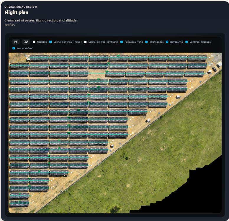
To meet the IEC TS 62446-3 radiometric requirement of at least 5x5 pixels per cell, the Mavic 3T's 640x512 thermal sensor has to fly low. Kira's flight envelope is 17 m above the panels, which produces 2.3 cm per pixel thermal GSD with a 24% safety margin below IEC's 3 cm/px ceiling. Standard drone GPS drifts 2 to 5 meters horizontally. At 17 m altitude with 80% frontal overlap and one frame every two seconds, that drift means the drone is no longer over the panel row it is supposed to image. Frames go off-string, viewing angle changes between blocks, and the radiometric measurement is contaminated.
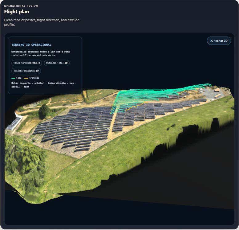
Terrain-following plus string-alignment is impossible without an RTK fix
Solar plants in southeastern Brazil sit on irregular terrain. Modules step up and down with the slope. A constant-altitude grid flight at 17 m above the highest panel pushes the lowest panel out of the IEC GSD window. Kira solves this by following the digital surface model module by module, holding 17 m relative to each row independently. That kind of altitude hold needs centimeter-grade vertical anchoring. Standard GPS cannot deliver it. RTK can.
The Solution: How Kira pairs DJI Mavic 3T with an RTK network
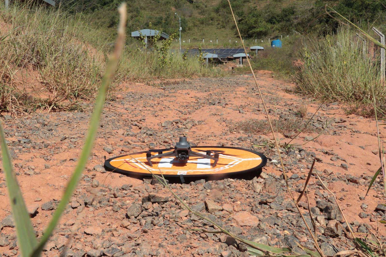
Rodrigo built Kira around a $5,000 DJI Mavic 3T because the methodology, not the hardware, is the differentiator. The Mavic 3T's 640x512 thermal sensor matches enterprise platforms like the M300 with H20T at one fifth the cost. What unlocks IEC compliance on the lower-cost airframe is precise georeferencing of every captured frame.
"Without the precise georeferencing provided by RTK, it is impossible to confidently link a solar module from a macro orthomap to the original, high-resolution image. RTKdata empowers our pipeline to execute perfectly string-aligned flights and extract bankable, IEC-compliant data, completely avoiding the stitching distortions that plague traditional platforms."Eng. Rodrigo L. Abrão, Founder, Kira
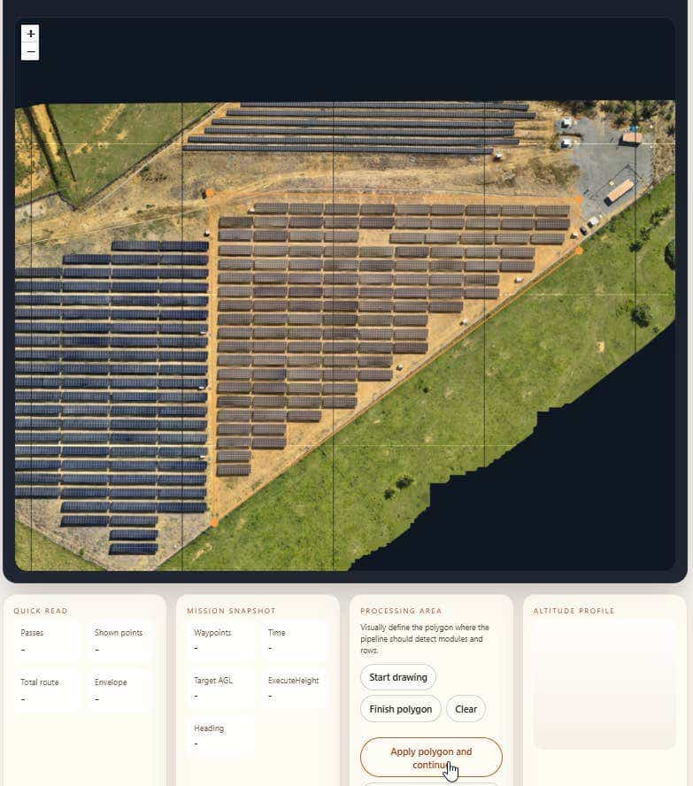
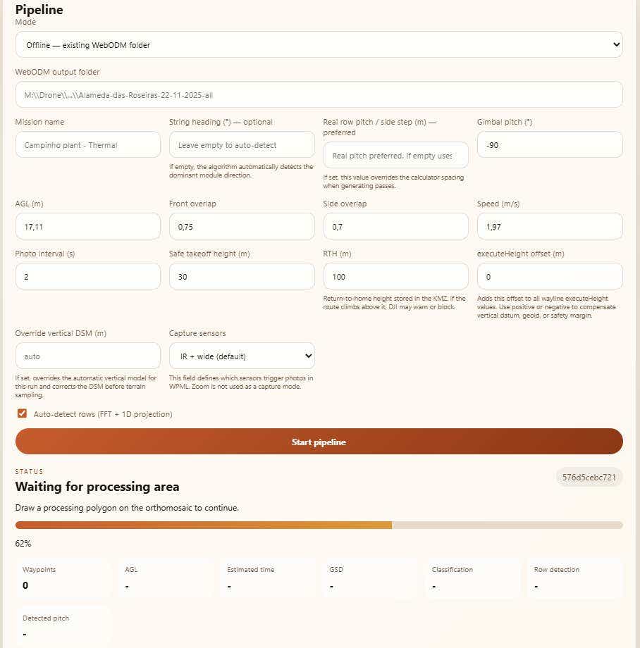
The Kira pipeline produces a proprietary KMZ flight plan from a plant orthomap. The KMZ encodes per-row waypoints aligned to module pitch, terrain-following altitude relative to each panel string, and gimbal control locked to the module tilt or to nadir at minus 90 degrees. Photos fire only over modules, not over empty terrain between blocks. RTK is what makes that KMZ executable in the field.
String-aligned KMZ flight path generation
Kira reads a baseline RGB orthomap of the plant, segments individual module rows, and emits a KMZ where each waypoint sits on a row centerline. The pilot loads the KMZ into DJI Pilot 2 on a Mavic 3T tied into a RTK base station network for drones over NTRIP. Once the receiver reaches RTK fix, the flight follows the row centerlines to within centimeters. Frame after frame captures the same module row at the same viewing angle, which is what the radiometric pipeline downstream needs.
Constant viewing angle and 2.3 cm/px GSD at 17 m
At 17 m altitude with the Mavic 3T thermal sensor, every frame resolves at 2.3 cm per pixel. With 80% frontal overlap concentrated on the panel rows rather than empty space between blocks, every solar cell is captured at minimum 5x5 thermal pixels per cell. That is the IEC TS 62446-3 floor for a defensible radiometric measurement. The viewing angle stays constant across the flight because the gimbal is locked to module tilt and the airframe stays perfectly aligned to the string. No off-axis frames. No oblique-angle outliers. No reflections from sun-glare misalignment.
Terrain-following at module-level precision
On irregular ground, Kira's KMZ steps the altitude row by row to keep 17 m relative to each module. The terrain-follow profile is generated from the digital surface model and executed against the RTK fix. This is the part of the workflow that genuinely cannot run on standard drone GPS. The position has to be locked tightly enough that the per-row altitude target is not lost in horizontal drift.
Why Kira chose RTKdata over local Brazilian alternatives
Rodrigo evaluated Brazilian RTK providers before settling on RTKdata. The Brazilian market has options. Most of them, in his words, suffer from bureaucracy and slow setup times that block a small drone services operator from getting into the field on a tight project window.
"Choice for RTKdata: extreme low barrier to entry, excellent technical recommendations."Eng. Rodrigo L. Abrão, Founder, Kira
Low barrier to entry vs Brazilian RTK bureaucracy
Local Brazilian RTK options often require contractual lock-in, regional licensing paperwork, or a physical base station purchase. For a startup running PoCs across multiple states, that overhead kills the workflow. RTKdata's NTRIP-only model meant Rodrigo could create an account, drop credentials into the Mavic 3T, and have RTK fix on the first mission of the day.
Setup speed in Minas Gerais and Vitória
Kira's primary operating regions are Minas Gerais and Vitória in southeastern Brazil. Centralized solar generation is also strong in the northeast. RTKdata's RTK coverage in Brazil anchors on the SIRGAS 2000 reference frame and works across all 26 states without the operator having to negotiate state-by-state base station access. For a Mavic 3T pilot, this means the same NTRIP profile works whether the day's mission is in Belo Horizonte or in the northeastern centralized plants.
Technical recommendations during onboarding
The other thing Rodrigo specifically called out: technical guidance during the trial period. For a low-altitude string-aligned thermography mission, the pilot needs to understand which constellations to enable, how to handle cellular dropouts on rural plants, and what fix-recovery behavior looks like at 17 m. RTKdata's support team gave him concrete recommendations. He stayed on the platform after the trial for that reason.
The Results: Fortlev PoC at 2 MWp
Fortlev is the world's largest manufacturer of polyethylene water tanks and a meaningful Brazilian solar asset owner. Kira ran a proof of concept on one of three Fortlev solar plants. The PoC site has roughly 3,192 modules and approximately 2 MWp of installed capacity. Rodrigo selected it because it has irregular terrain, mixed module orientations between blocks, and the kind of access-and-time constraints that punish a generic grid-flight workflow.
3,192 modules indexed against raw radiometric photos
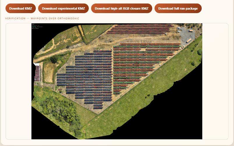
Every one of the 3,192 modules at the Fortlev PoC plant was indexed against the raw, unstitched thermal photo that captured it. The radiometric measurement for each defect call traces back to a specific frame, a specific pixel range, and a specific RTK-anchored waypoint. There is no orthomosaic stitching in the measurement chain. The orthomosaic is used only as a spatial reference for the report viewer, not as the source of truth for the thermal data.
12 m/s acceleration between blocks vs constant DJI-Pilot speed
Rodrigo's KMZ generator emits a non-uniform speed profile. The drone captures at 2 m/s over the panel rows, then accelerates to 12 m/s in the gaps between module blocks where no images need to be captured. Standard DJI Pilot 2 missions hold a constant capture speed across the entire grid. On an irregular plant with significant non-panel space between blocks, the constant-speed flight wastes battery and time on terrain that produces no usable frames. Kira's variable-speed profile is one of the operational reasons the methodology runs on a $5,000 drone instead of needing a multi-battery enterprise rig.
Defect calls traceable to source frame, not orthomosaic
The Fortlev PoC report routes every defect call back to the original Mavic 3T thermal frame, the RTK-anchored capture position, and the IEC TS 62446-3 5x5 pixel-per-cell radiometric window. For a Perito Judicial report or an insurance audit, the traceability chain is the asset, not the heatmap.
- 17 m altitude, terrain-following per module
- 2.3 cm/px thermal GSD on Mavic 3T at 17 m, 24% margin below IEC ceiling
- 80% frontal overlap concentrated on panel rows
- 2 m/s capture speed, 12 m/s acceleration between blocks
- 3,192 modules indexed at the Fortlev PoC plant
- ~2 MWp plant size for the PoC
- 1-2 cm RTK positional accuracy at low altitude (vs 2-5 m drift on standard drone GPS)
Customer Testimonial
"RTKdata is what allows the Kira pipeline to reverse the industry standard. Instead of forcing users to measure anomalies on stitched, blurred orthomosaics, RTK provides the precise georeferencing needed to trace any module on the map back to the raw, unstitched thermal photo. It's the anchor that guarantees untouched radiometric truth for every single solar cell."Eng. Rodrigo L. Abrão, Founder, Kira / Perito Judicial, CREA-MG 0000231626D
The forensic engineering background is what frames Rodrigo's standards for the methodology. As a court-appointed expert, his reports have to survive cross-examination. That same standard now drives the Kira pipeline he sells to commercial solar operators.
Technical Setup
| Component | Detail |
|---|---|
| Drone | DJI Mavic 3 Enterprise (Mavic 3T thermal variant) with RTK module |
| Thermal Sensor | 640 x 512 radiometric, IFOV 1.33 mrad |
| Correction Service | RTKdata NTRIP RTK (cloud-based) |
| Correction Format | RTCM 3.2 |
| Constellations | GPS, GLONASS, Galileo, BeiDou |
| Connectivity | Cellular hotspot to NTRIP client on Mavic 3T |
| Reference Frame | SIRGAS 2000 (Brazil network alignment) |
| Mission Altitude | 17 m above modules, terrain-following per row |
| Thermal GSD | 2.3 cm/px (24% margin below IEC 3 cm/px ceiling) |
| Frontal Overlap | 80%, concentrated on panel rows |
| Capture Cadence | 1 frame per 2 seconds at 2 m/s, 12 m/s in non-panel gaps |
| Compliance Target | IEC TS 62446-3 (5x5 px/cell radiometric requirement) |
| Base Station Required | None |
| Setup Reference | DJI Mavic 3T RTK setup guide |
What's Next: Major Solar Plants in Negotiation
Kira is in negotiation with several larger solar plant operators in Brazil after the Fortlev PoC. Rodrigo is also raising an investment round on the back of the commercial proof. The methodology pitch deck is online at kira-thermo-pitch.vercel.app, with the full GSD math, the IEC compliance frame, and the three-tier analysis pipeline that ties the orthomap, the raw RGB frame, and the raw thermal frame together.
For RTKdata, Kira is the kind of operator the platform is built for: a skilled pilot who knows exactly what RTK has to deliver and why, running a methodology where standard GPS would not just be inconvenient but would invalidate the entire compliance chain.
Frequently Asked Questions
Why does RTK matter for low-altitude solar drone inspection?
Low-altitude thermography missions at 17 m above panel rows need centimeter horizontal and vertical accuracy. Standard drone GPS drifts 2 to 5 meters, which is enough to push frames off the panel string they are supposed to image. RTK locks the position tightly enough that every frame captures the intended row at the intended viewing angle, which is what an IEC TS 62446-3 audit requires.
Can a DJI Mavic 3T fly RTK missions for thermography?
Yes. The DJI Mavic 3 Enterprise platform, which includes the thermal Mavic 3T variant, supports an RTK module that connects to NTRIP correction services like RTKdata over a cellular hotspot. Once RTK fix is achieved, the Mavic 3T can fly cm-accurate string-aligned KMZ missions at 17 m altitude with terrain-following per row. The thermal sensor is 640 x 512 radiometric.
What RTK fix rate do I need for solar PV inspection?
For a defensible IEC-grade inspection, the receiver needs to hold RTK fix consistently above 95 percent during capture windows. The methodology depends on every frame being georeferenced. Brief fix dropouts in transit between blocks are tolerable as long as the drone reaches fix again before the next capture row. Operators should test fix behavior on their specific site before booking commercial work.
How do I choose an RTK provider for drone inspection in Brazil?
Pilots running solar inspections in Brazil should evaluate three things: regional coverage on the SIRGAS 2000 reference frame, setup speed without contractual lock-in, and quality of technical recommendations during onboarding. Local Brazilian options can be slow and bureaucratic. Cloud NTRIP services with monthly billing and instant credentials let a pilot get into the field on the same day they sign up.
What is the difference between standard GPS and RTK for thermography missions?
Standard drone GPS gives 2 to 5 meter horizontal accuracy and similar vertical drift, which is unusable at 17 m altitude over discrete panel rows. RTK delivers 1 to 2 cm horizontal accuracy in real time when the drone is within range of an NTRIP correction stream. For thermography, that difference is what lets the pilot fly string-aligned with terrain-following and produce raw radiometric frames that survive an audit.