

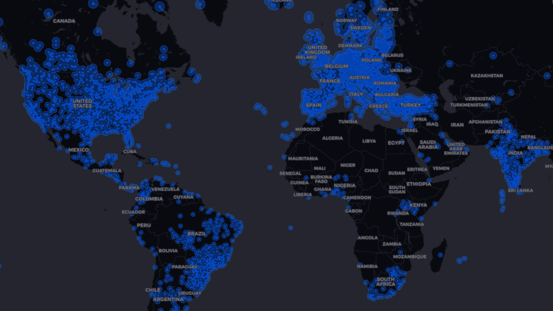
A GNSS corrections map shows where a correction service can deliver corrections and roughly what accuracy to expect at each location. For RTK, that mostly comes down to how far you are from the nearest reference station.
A map is a planning tool. It predicts what is possible at a location; it does not measure the conditions on your site. This guide explains what corrections maps show for each type of correction, how to read RTKdata's coverage map, and what to check before relying on it.
- A GNSS corrections map predicts the accuracy you can expect at a location. It does not measure conditions on your site.
- RTK maps are drawn around reference stations, because RTK accuracy depends mainly on the distance to the nearest one.
- On RTKdata's map, the 2 cm zone means RTK FIX is reliable at survey grade. The 2–10 cm zone suits mapping, guidance and layout.
- Before a job, check the exact site, sky view and mobile data, then test against a known point.
What a GNSS corrections map shows
Standalone GNSS is too coarse for precision work. GPS.gov notes that GPS-enabled smartphones are typically accurate to within a 4.9 m radius under open sky, and worse near buildings, bridges and trees. Corrections from reference stations at known positions reduce the errors that the station and your receiver share, such as satellite orbit and clock errors and atmospheric delay.
A corrections map shows where those corrections are available. Depending on the service, it marks reference-station locations, the area where a given accuracy is expected, or both. RTK accuracy falls as the distance to the reference station grows, which is why RTK maps are drawn around stations. Our guide to how distance affects NTRIP RTK accuracy explains why.
Correction types and their coverage
Different kinds of corrections have very different footprints and accuracy. A map is only useful if you know which kind it describes.
- SBAS (satellite-based augmentation, such as WAAS in North America and EGNOS in Europe) broadcasts corrections from geostationary satellites over a whole region. The EGNOS Open Service definition commits to 3 m horizontal and 4 m vertical accuracy at 95%.
- DGNSS, classic code-based differential correction, uses a reference station to correct code measurements. Navipedia puts DGPS accuracy at about 1 m for users within a few tens of kilometers of the station, degrading with distance.
- RTK uses carrier-phase measurements from a nearby reference station or network. With suitable equipment and conditions, it reaches centimeter level, but only within range of stations.
- PPP and PPP-RTK use precise satellite orbit and clock data instead of a nearby station, so they work over much wider areas but need time to converge. PPP-RTK adds regional atmospheric corrections to shorten that wait. Galileo's free High Accuracy Service, for example, at full service targets better than 20 cm horizontally within 300 seconds worldwide, and within 100 seconds in Europe.
RTKdata's coverage map shows RTK coverage: where the reference stations are and the accuracy you can expect near them.
Open RTKdata Docs
Explore formats like RTCM and delivery via NTRIP to align correction types with your receivers and regions.
How to read RTKdata's coverage map
The RTKdata coverage map uses two colored zones, labeled 2 cm and 10 cm in the map legend. According to our accuracy guidance:
- 2 cm zone: RTK FIX is reliable and accuracy is survey grade.
- 2–10 cm zone: RTK FIX is achievable but may take longer. Horizontal positions are typically within 2–10 cm, and vertical accuracy is 1.5 to 2 times worse. That suits drone mapping, agricultural guidance and general construction layout, but not survey control points, precise boundary surveys or other work that needs better than 2 cm.
- Outside the colored areas: there is no nearby base station, and accuracy depends on the distance to the nearest one. Our coverage map guide notes that some areas have coverage beyond what the map shows, so test on site if you are outside or near the edge.
For the best results, our documentation recommends working within 15 km of a base station.
Start your 30-day free trial
Validate cm-level positioning on your routes and sites in the regions you care about.
What the map cannot show
A GNSS corrections map predicts accuracy from station distance. Conditions at your site can still make the result worse:
- Sky view: buildings, tree canopy and terrain block satellites. Our documentation rates open ground with nothing above 15 degrees elevation as best, and urban canyons and dense forest as poor.
- Multipath: signals reflected off buildings, vehicles or metal structures distort measurements. Our documentation calls it the biggest cause of lost accuracy after distance, and our multipath guide explains how to work around it.
- Internet connection: corrections must arrive in real time. Our documentation gives full RTK performance below 1 second of latency, slightly degraded results with more FLOAT likely between 1 and 3 seconds, and stale corrections above 3 seconds. Mobile data coverage is a separate check from correction coverage.
- Atmosphere: ionospheric activity, for example during solar storms, can degrade RTK, especially farther from the base.
- Receiver and antenna: the result depends on what your equipment can track and how well it handles difficult signals. Our receiver guide covers what to look for.
How to check coverage before a job
Treat the GNSS corrections map as the first check, not the only one:
- Find the exact site on the map, not the nearest town. Accuracy changes with distance, so a field or site boundary can sit in a different zone from the town center.
- Match the zone to your tolerance. Survey control and boundary work need the 2 cm zone. Mapping, guidance and layout can often work in the 2–10 cm zone, as long as the weaker vertical accuracy is acceptable.
- Check the site for sky view and reflecting surfaces.
- Check mobile data at the site, because NTRIP corrections arrive over the internet. Our NTRIP guide explains how corrections reach your receiver.
- Test before the real job. Connect on site, give RTK 60 to 90 seconds to converge, and check the fixed solution against a known point before collecting data.
When the map shows no coverage
If your site is outside the colored zones, first test on site, since coverage can reach beyond what the map shows. If corrections still do not reach your site, there are three main options:
- Run your own base on site and send corrections by radio or NTRIP. Our base-station guide covers when that is worth it.
- Host an RTKdata base station if you work regularly in an area with limited coverage. You provide a spot with a clear sky view, USB-C power and 2.4 GHz Wi-Fi. RTKdata provides the station and gives you 50% off one RTK subscription for as long as it stays online. See Host a Base Station for the requirements.
- Use a PPP service if decimeter-level results are enough for the job and you can wait for convergence.
Plan your rollout with RTKdata
Discuss regional coverage, accuracy targets, and integrations, or try live corrections on your routes.
Frequently asked questions
What is a GNSS corrections map?
It shows where a correction service can deliver corrections and roughly what accuracy to expect at each location. RTK maps are drawn around reference stations, because RTK accuracy depends mainly on the distance to the nearest station. The map predicts accuracy; it does not measure conditions on your site.
How accurate is GNSS with corrections?
It depends on the type of correction. EGNOS commits to 3 m horizontally at 95% in Europe, classic DGPS reaches about 1 m near its reference station, and Galileo's High Accuracy Service targets better than 20 cm at full service. RTK reaches centimeter level, and RTKdata's 2 cm zone marks where RTK FIX is reliable at survey grade.
What's the difference between RTK, PPP and PPP-RTK?
RTK uses a nearby reference station or network and reaches centimeter level quickly, but only within range of stations. PPP uses precise satellite orbit and clock data, so it works almost anywhere, but it needs time to converge. PPP-RTK adds regional atmospheric corrections to shorten that wait.
What does the 2–10 cm zone on the RTKdata map mean?
RTK FIX is achievable but may take longer, and horizontal positions are typically within 2–10 cm. Vertical accuracy is 1.5 to 2 times worse. That suits drone mapping, agricultural guidance and general construction layout, but not survey control points, precise boundary surveys or other work that needs better than 2 cm.
How can I test coverage for my site?
Find the exact site on the coverage map and match the zone to your tolerance. On site, check sky view and mobile data, connect, wait for a fixed solution, and check it against a known point. The 30-day trial lets you do this with your own equipment before committing.

Inbound and outbound sales for SMB and mid-market customers at RTKdata.