

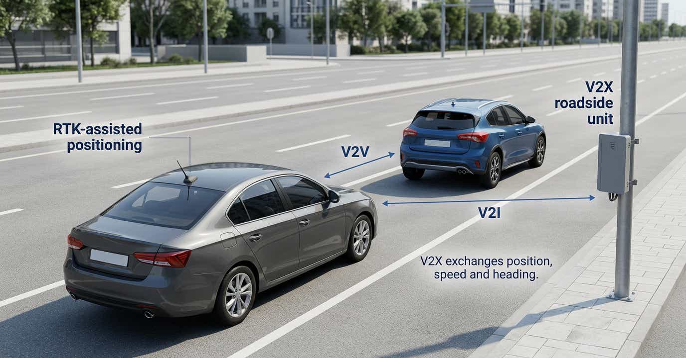
V2X communication exchanges information between vehicles and their surroundings; RTK improves GNSS positioning using reference-station data, so the two can work together without either replacing the other.
A vehicle can receive a warning promptly and still misunderstand where the hazard is. V2X communication supplies shared information, while the positioning system must establish where that information belongs. The engineering question is which position accuracy a particular application needs, and whether it remains available along the route.
For teams evaluating connected car technology, this distinction separates a communications purchase from a localization decision. RTK can contribute precise coordinates, but a correction subscription alone does not establish dependable collision avoidance or automated driving.
V2X: Vehicle-to-Everything
V2X describes a family of communications capabilities, rather than one positioning method or a single standard. A connected vehicle can exchange information with other equipped vehicles, roadside infrastructure, participating pedestrian devices and network services. The message content, radio technology and application logic are separate parts of that system.
V2V communication supports exchanges between vehicles, such as information about movement or braking. V2I communication links a vehicle with infrastructure: a roadside unit might provide signal timing or intersection information. V2P concerns pedestrians and other vulnerable road users; V2N connects the vehicle with network services. These categories identify the communicating parties, not the accuracy of their coordinates. [14]
For cooperative awareness, receiving information beyond the view of onboard sensors can be valuable. However, a reported object still needs a timestamp, a usable spatial reference and enough quality information for the receiving application. Receiving a message successfully does not prove that its position is correct.
Imagine an approaching vehicle hidden behind a building. Its transmitted location could help another vehicle anticipate a conflict. Whether the warning is appropriate also depends on heading, speed, road geometry and uncertainty. A communications link extends the information available to the application; it does not decide what driving action is safe.
DSRC vs. C-V2X: The Two Ways Vehicles Talk
The two established radio families are IEEE-based short-range communication and cellular-derived vehicle communication. DSRC (Dedicated Short-Range Communications) in the US developed around IEEE 802.11p; the related European approach is ITS-G5. Cellular V2X includes direct communication through the PC5 sidelink and connectivity through a mobile network's Uu interface. [2]
The word “cellular” can therefore mislead. Direct communication can operate without a mobile-network subscription or coverage in the relevant operating mode. Network communication depends on the mobile connection. Neither the existence of a direct radio nor a working modem tells you whether a correction-data service has been integrated. [1]
| Delivery path | What it connects | Meaning for correction delivery |
|---|---|---|
| IEEE-based short-range link | Nearby equipped stations | Roadside correction broadcasts are possible with suitable messages and equipment. |
| Cellular direct sidelink | Nearby equipped stations | A direct link is not automatically an internet connection to an NTRIP caster. |
| Cellular network connection | Vehicle and remote services | An onboard NTRIP client can receive corrections through an ordinary IP connection. |
It would be incorrect to say short-range infrastructure cannot deliver RTK corrections. ETSI TS 103 301 explicitly defines a GNSS positioning correction service using RTCMEM messages, including RTK data, with short-range broadcast requirements. That is a supported architecture, not evidence that every roadside deployment provides it. [3]
For procurement, ask which correction source, application messages and receiver interface the proposed installation actually supports. The radio-family label alone is insufficient.
Why V2X Can Benefit from RTK
RTK uses carrier-phase observations and reference-station information to improve a compatible GNSS receiver's solution. [16] RTKdata documents internet delivery of correction data through NTRIP. The vehicle still needs suitable receiving hardware, an antenna installation and software that accepts those data. [4]
V2X communication can share the resulting position with other participants. It can also operate with positions produced by other methods. An RTK receiver is therefore a possible input to an application, not a prerequisite for every traffic-information exchange.
The case for precision becomes stronger when a system must distinguish adjacent lanes, associate observations with a detailed map or locate the vehicle within a narrow operating area. Even then, absolute GNSS accuracy is only part of the problem: map alignment, vehicle orientation and the position of the antenna relative to the vehicle body also matter.
A connected vehicle may combine advanced driver assistance systems (ADAS), platooning or geofencing with shared traffic information. Define the task first: maintaining separation in a platoon, assigning a lane and checking a geographic boundary do not demand identical position outputs. V2X communication provides a way to share relevant information.
Absolute vs. relative position: what V2X actually requires
Absolute position locates a vehicle in a defined reference frame, enabling comparison with a map, a lane boundary or a geofence. Relative position describes where another object is with respect to the vehicle. Collision assessment often depends on relative motion, while map-based lane assignment requires consistent vehicle and map coordinates.
Shared GNSS errors can partly cancel when nearby receivers observe common satellites under comparable conditions. That does not mean subtracting any two reported coordinates produces a precise separation. Different satellite visibility, receiver processing, measurement times and local reflections leave errors that are not shared. Shen and colleagues' 2017 cooperative-localization research explicitly separates common pseudorange biases from receiver-specific multipath errors. [5]
Consider an explicitly simplified example. Two vehicles are truly 20 m apart along a straight road. If both positions contain the same +2 m offset, subtraction still gives 20 m. If only one receiver also suffers an additional +1 m local error, the calculated separation becomes 21 m. This arithmetic illustrates cancellation; it is not a predicted road-test result.
Both vehicles could also appear displaced against the lane map despite their correct mutual separation. Conversely, precise map coordinates become less useful for collision assessment if they describe different moments. Relative and absolute positioning support each other; selecting one does not eliminate the need to understand the other.
The accuracy bar, by use case
There is no universal V2X communication accuracy requirement. A broad warning, a pedestrian-conflict application and autonomous vehicle positioning make different demands. Published numbers also mix desired performance, measured accuracy and maximum tolerable error. Those categories should remain visible.
| Application or comparison | Sourced accuracy example | How to interpret it |
|---|---|---|
| Broad situational awareness | Metre-scale positioning may be relevant; EGNOS Open Service specifies 3 m horizontal accuracy at 95% under its stated conditions. [6] | A non-safety-critical Open Service example under defined conditions, not a universal traffic-warning requirement or guaranteed road performance. |
| Vulnerable-road-user conflict applications | A 2017 cooperative-ITS study identifies 0.5 m as a desired accuracy for distinguishing a sidewalk from the roadway. [7] | A use-case-specific research target, not a requirement for all collision-avoidance systems. |
| Position within a lane | Highway research distinguishes lane determination below 1.5 m from where-in-lane positioning below 0.3 m. [8] | Knowing which lane differs from knowing where within that lane the vehicle sits. |
| Automated-driving localization | Reid and colleagues derive 0.20 m lateral accuracy at 95% for freeway conditions and 0.10 m lateral and longitudinal accuracy at 95% for local streets. [9] | Derived requirements under stated road and vehicle assumptions, not a universal certification threshold. |
The often-quoted 10–30 cm range therefore needs context. It can describe demanding localization objectives, but lane-level accuracy is not one fixed number. Likewise, the 0.29 m local-street alert limit in Reid's analysis is not interchangeable with its 0.10 m accuracy requirement. [9]
Specify the axis, confidence level, required availability and response to an unreliable estimate. A receiver's typical open-sky accuracy cannot establish those system-level properties by itself.
How RTK Corrections Actually Reach a Moving Vehicle
For an NTRIP installation, corrections reach the receiver over an internet connection. BKG documents the protocol; RTKdata's quick start explains the service setup. [15][4]
- A reference network makes correction data available through an NTRIP caster.
- An onboard client connects over an available IP link, commonly a cellular modem, using the configured service credentials and mountpoint.
- Where the service requires it, the client supplies approximate position through NMEA GGA so the caster can select a suitable stream.
- The client feeds compatible correction messages into the GNSS receiver, which combines them with its satellite observations.
- The localization software evaluates the receiver output and its quality before making it available to navigation or other applications.
RTKdata's AUTO selects the nearest reference station using the reported rover position. Check station coverage throughout the route: internet access alone does not ensure a nearby station. [10]
This path resembles V2N connectivity because it connects the vehicle to a remote service. NTRIP is the application protocol, distinct from the Uu radio interface. Correction subscriptions and mobile connectivity remain separate dependencies. [15]
V2X communication can then share the estimated vehicle state. Broadcasting corrections is a separate function requiring a correction source, suitable messages and integration. [3]
Time alignment also matters. At 20 m/s, a vehicle travels 2 m in 100 ms. That distance is not automatically a positioning error: synchronized timestamps and motion estimation can compensate. Nevertheless, precise old coordinates cannot replace a current state estimate.
Finally, log correction outages separately from blocked or reflected satellite signals. Outages interrupt correction data; obstructions and reflections affect satellite observations. These logs help explain FIX loss and recovery.
What V2X Can and Cannot Fix About GNSS
An urban canyon can block direct satellite paths and create multipath from nearby buildings. Vehicles on opposite sides of the same street may experience different reflections. RTK corrections from a reference station do not automatically remove those local effects. RTKdata's accuracy guidance explicitly identifies sky view, distance and internet stability as relevant conditions. [11]
In a tunnel without usable satellite reception, ordinary GNSS RTK cannot keep producing new satellite-based positions simply because corrections remain available. V2X communication can still carry information where a communication path exists, but exchanging messages does not recreate missing carrier-phase observations.
Sensor fusion addresses a different part of the problem. An IMU can propagate motion between external updates, although its estimate drifts without suitable aiding. VectorNav's GNSS/INS primer explains this complementary relationship. [17] Cameras, LiDAR, radar or wheel measurements can provide other constraints in an appropriately designed system. The integration must manage uncertainty rather than assume uninterrupted precision. RTKdata also discusses sensor fusion for reliable localization.
Roadside assistance also needs precise language. A surveyed GNSS base can provide corrections where the vehicle still receives usable satellites. A separately engineered roadside sensing or ranging system may provide other localization information. These are different functions; calling both “V2I” does not make their capabilities equivalent. [3]
For an evaluation, record the conditions around each transition: open road to underpass, clear sky to buildings, or stable mobile coverage to a handover. Compare the estimated trajectory with a suitably accurate independent reference. Measuring time in FIX is useful, but it does not independently establish that every fixed position is correct.
Where RTKdata Fits in This System
RTKdata supplies GNSS corrections through a documented NTRIP connection. A team evaluating RTK for transportation can assess that service as an input to its positioning system. It should separately establish the capabilities of the vehicle radio, application software, localization components and safety architecture.
A correction service does not by itself implement a complete standards-compliant vehicle messaging system. Nor should access to corrections be presented as approval for automated steering, braking or collision avoidance. No automotive safety certification or vehicle-radio integration is established by the documentation cited here.
The practical assessment has two parts. First, establish that the receiver accepts the stream and produces the expected output under suitable conditions. Second, determine whether the integrated application meets its requirements across the intended route. For background on positioning performance, see how RTK corrections work over NTRIP.
Coordinate consistency belongs in that assessment. RTKdata documents regional reference frames and height handling; the vehicle output and project map must be interpreted consistently. A small repeatability figure does not resolve a mismatch in datum, epoch or height convention. The coordinate systems and datums guide provides the service-specific starting point. [12]
For autonomous vehicle positioning, define acceptance criteria before interpreting a trial: route coverage, recovery behavior, timestamp handling, map alignment and error against an independent reference. A successful correction connection is the beginning of that evaluation.
The Regulatory and Standards Context
In the US 5.9 GHz band, the FCC's 2020 decision reassigned the lower 45 MHz of the former 75 MHz transportation allocation for unlicensed use and retained the upper 30 MHz, 5.895–5.925 GHz, for intelligent transportation systems. Its November 2024 order adopted final technical and service rules for the transition to cellular vehicle communication. This is US spectrum policy, not a worldwide operating authorization. [13]
The technology timeline is separate. 3GPP's LTE-based vehicle sidelink work was completed in Release 14 in 2017; Release 16 introduced the NR-based evolution in 2020. Those milestones describe successive capabilities, not a requirement that every application uses the newest generation. [2]
5GAA is an automotive and telecommunications industry association that supports deployment, collaboration and contributions to standardization. Its reports help explain use cases, but the association is not the spectrum regulator. [1]
For a deployment, identify the applicable regional spectrum rules, radio generation, message standards and equipment approvals. V2X communication and GNSS correction delivery must each be assessed at the relevant layer. A compliant radio does not establish positioning integrity, and accurate coordinates do not establish radio compliance.
Source note: References were checked on 14 September 2026. The dated standards and studies describe their stated versions, assumptions and test conditions.
FAQ
What is V2X?
It is communication between vehicles and other vehicles, infrastructure, participating pedestrian devices or network services. It shares information that an application can use for awareness or coordination. RTK addresses positioning, so it can supply one input without replacing the communication system. [14]
How does RTK work?
A compatible GNSS receiver combines satellite carrier-phase measurements with reference-station information to estimate its position more precisely. In an NTRIP installation, the correction data arrive over an IP connection. Results depend on the receiver, usable satellite observations, reference data and operating conditions. [16][15]